Cyclone DANA likely to be a severe one: Indian Met
- Update Time : Wednesday, October 23, 2024
Bangladesh’s Khulna, Barisal, Patuakhali likely to suffer
TDS Desk
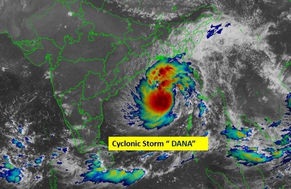
The cyclonic storm DANA is likely to move towards the northwest and intensify into a severe cyclonic storm over northwest Bay of Bengal by early morning on Thursday, said the latest bulletin released by the Indian Meteorological Department.
There are expectations that the southwestern coastal districts of Khulna, Barisal, Patuakhali, Barguna, and Bhola could be hit hard by the impact of the cyclone, as these areas are located on the right side of the storm’s expected landfall zone in Odisha, India.
“The cyclonic storm over East central Bay of Bengal moved northwestwards with a speed of 15 kmph during past 6 hours and laying centred at 08:30 IST (Indian Standard Time) on Wednesday over a region located about 520 km southeast of Paradip (Odisha), 600 km south-southeast of Sagar Island (West Bengal) and 610 km south of Khepupara (Bangladesh)”, said the bulletin released 11:45 IST (Indian Standard Time).
It may cross north Odisha and West Bengal coasts between Puri and Sagar Island close to Bhitarkanika and Dhamara (Odisha) during the night of 24 October to morning of 25 October, with a wind speed of 100-110 kmph gusting 120 kmph.
Maximum sustained wind speed within 54km of the cyclone centre is about 62 kph rising to 88 kph in gusts or squalls.
The seawaters will remain very rough near the cyclone centre. Maritime ports of Chattogram, Cox’s Bazar, Mongla and Payra have been advised to hoist local cautionary signal No. 3.
All fishing boat and trawler over North Bay and deep sea have been advised to take shelter immediately.


