
While WDB driver turns to hydrographic engineer!
- Update Time : Tuesday, September 2, 2025
Staff Reporter:
It seems unbelievable, but truth that, a driver of the Bangladesh Water Development Board’s Sirajganj district office has now turned into an engineer for its hydrographic section.
The lucky person name is Abdur Rashid, who joined in the WDB as a driver. Now he is serving as assistant hydrographic surveyor at the WDB’s district office based on a contract.
Rashid said, “I have learnt the hydrographic survey works, while working in Hyundai Company. Now, I have become a master of the hydrographic survey related works. Not only that, I have gathered a three months training certificate from an institute.”
But, he declined to say the name of that institution, which has provided the certificate.
When asked about him, Mokhlesur Rahman, Executive Engineer of the WDB said, “We have no adequate fund in this purpose. Besides, we have no permission to recruit such as staff or employee to conduct hydrographic survey in the river. So, we carry the work by our driver on a contractual base.”
When he was asked again about the acceptability and standard of the hydrographic survey report produced by the former driver, he said, “We send it to our relevant senior officers to verify and then they produce a final report on it. But, I personally have no idea about its standard as I have no expertness on it.”
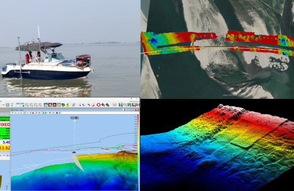
THE IMPORTANCE OF HYDROGRAPHIC SURVEY IN THE RIVER
Hydrographic surveys are important for rivers as they map the underwater terrain to ensure safe navigation for boats, support planning for construction projects like bridges and harbors, enable effective management of dredging and siltation, aid in flood control efforts, and support environmental monitoring and fisheries management by providing detailed bathymetric data. The data collected creates charts and 3D models crucial for safety, economic activity, and scientific understanding of river systems.
KEY REASONS FOR HYDROGRAPHIC SURVEYS IN RIVERS
Navigation Safety:
Surveys map water depths, identify submerged obstructions like rocks, and chart river channels to prevent accidents and ensure smooth passage for vessels.
Infrastructure development:
Accurate depth and seabed data are vital for the design and construction of bridges, docks, and other river-based infrastructure.
Flood Control and Management:
Hydrographic data helps in understanding river flow and bed characteristics, which is essential for effective flood control measures.
Dredging and Siltation Control:
Surveys monitor riverbed changes and are crucial for planning and executing dredging operations to maintain navigable depths.
Environmental Monitoring:
Data from these surveys supports scientific research on river ecosystems, the impact of climate change, and the management of fisheries.
Resource Management:
Hydrographic surveys inform decisions related to water resource management, such as irrigation projects.
Mapping and Data Products:
The primary output is a hydrographic chart or a 3D digital terrain model, providing detailed information on underwater topography for various applications.
Waterway Use:
The data supports the efficient and safe use of waterways for transportation and commercial activities, impacting the livelihoods of communities that depend on them.


Editor & Publisher: Golam Mostafa Jibon
News & Commercial Office:
Railgate, Sirajganj & 2 R. K Mission Road, Dhaka.
Hotline: 01715-319996, 01558-314179
E-mail : [email protected]